Italian National Agency for New Technologies, Energy and Sustainable Economic Development

Environment: ENEA with forestry Carabinieri to measure air quality in parks
Measuring air pollution and landscape visibility in Italian nature parks. This is the objective of project “Visibility”, coordinated by the Forestry, Environmental and Agri-food Command Unit (CUFA) of the Carabinieri in partnership with the ENEA Air Pollution laboratory. The project will apply, for the first time in Italy, the procedure adopted by the U.S. Environmental Protection Agency (EPA) for measuring visibility in America’s nature reserves.
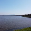
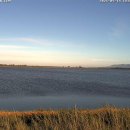
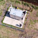
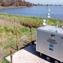
For the pilot action, the project team selected the Circeo National Park (Latina) as the first Italian sample area. The measuring instruments were positioned on Lake Monaci. “Currently this is the only visibility monitoring site in Europe, but soon the project will have a second measuring station located in the mountains”, states Lt. Col. Giancarlo Papitto, director of CUFA’s Projects, Conventions and Environmental Education Office and the project leader.
“Visibility is a useful physical parameter for evaluating the air quality in natural areas with significant tourism, like Italy’s national parks. In these places, the ability to enjoy a clear panorama, immersed in a natural landscape, provides priceless recreational value and a true service to the ecosystem. It is a good safeguarded by the Constitution and Italian laws to protect natural beauty”, underlines Ettore Petralia, a researcher at the Air Pollution Laboratory and the director of the project for ENEA.
“The measurement campaign will last two years. It will allow us to test the American UNPROVEN protocol in Italian parks[1]. This way, we will be able to quantify the visibility of the natural landscape, associating potential decreases in the parameter with pollution from atmospheric particulates of both human and natural origin”, the researcher explains.
ENEA researchers will be tasked with performing the chemical-physical analysis of the collected samples in the laboratory and calculating the atmospheric visibility index. Specifically, variations in the visibility of the horizon in photos will be analysed in correlation with the compositional data of atmospheric pollutants, following the IMPROVE method.
The forestry Carabinieri will be responsible for the overall coordination of the venture, including relations with U.S. authorities, weather data collection, management of the camera and sending the sampled filters to the ENEA team. In addition, they will be responsible for monitoring the measurement site, classified as a ‘sensitive objective’ for the potential and significant impact on human health of air pollution, which may result from human activities in the area, such as agriculture and stock farming.
In detail, the IMPROVE methodology is based on the quantification of a coefficient that describes the extinction of light as a function of several chemical-physical parameters associated with airborne molecules and particles, in this case, linked to atmospheric pollution. The project calls for 24h sampling for an entire calendar year (with a frequency of once every three days) to measure particulate concentration (PM2.5 and PM10) and nitrogen dioxide (NO2). The visual detection of the degree of air transparency will instead be ensured by a panoramic video camera, fixed to the outside of the station, which points in the direction of a landmark (in the case of the pilot action, Mount Circeo) taken as a reference for the definition of long-distance visibility. The camera is programmed to independently activate every 3 days in conjunction with atmospheric particulate sampling by other instruments. This schedule provides for a shot every 5 minutes throughout the day (during daylight hours, in relation to the sun’s height above the horizon). It switches off automatically when the pyrometer of the weather unit detects that solar radiation, and therefore natural light, has fallen to a minimum threshold. It is reactivated the next morning at dawn, again due to a signal sent by the solar radiation sensor. The measuring station is also equipped with a weather unit composed of an anemometer (for measuring wind speed and direction), pyrometer (for measuring solar radiation), thermohygrometer (for measuring air temperature and humidity), pluviometer (for measuring the quantity of rain), and barometer (for measuring atmospheric pressure). The weather data are continuously collected every 5 seconds and aggregated in hourly averages and daily minimums/maximums.
“Impaired visibility is probably the most easily recognisable effect of pollution in the atmosphere. Through the Visibility project, we will help protect and preserve this resource for future generations”, concludes Petralia.
All Visibility Italia activities are part of the LIFE MODERn (NEC) project, coordinated by CUFA in partnership with Legambiente. ENEA, CNR, CREA, the University of Florence, University of Camerino and TerraData Environmetrics Srl will participate. “The aim of this program is to respond to the requirements of the European NEC Directive[2], which commits Member States to reduce air emissions of certain pollutants by enacting national air pollution control programs and to monitor the effects of air pollutants on natural, seminatural, forest and freshwater ecosystems since these pollutants are dangerous not only for human health, but that of natural environments”, concludes Papitto.
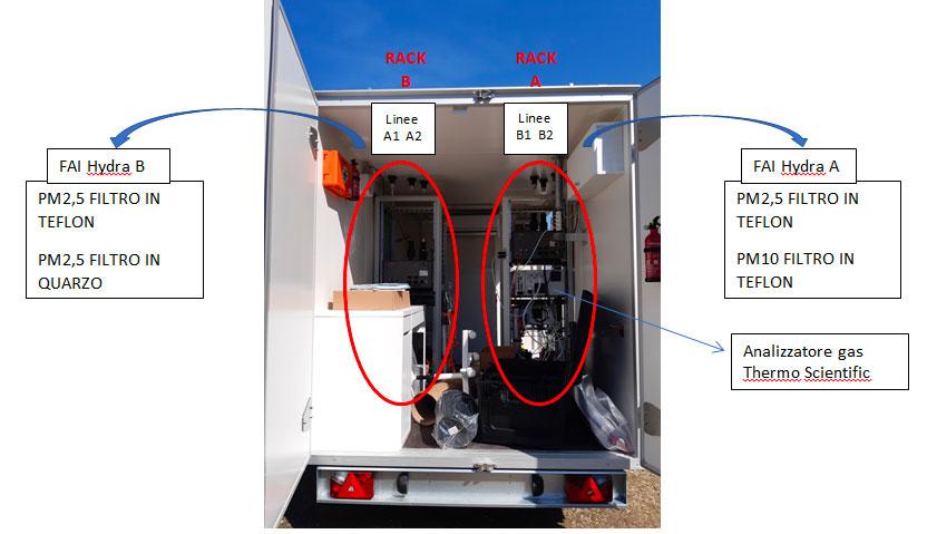
Figure 1 - Representative images of the transportable cart for atmospheric particulate samplers and the NOx monito
Photo gallery