
Italian National Agency for New Technologies, Energy and Sustainable Economic Development

Mobility: ENEA tests AI technologies for monitoring pedestrian flows
Improving safety and making cities more liveable with AI monitoring of pedestrian flows in crowded areas is the objective of a study ENEA conducted in Milan as part of the project CityFlows, funded by the European Institute of Innovation and Technology (EIT), whose outcomes were published in the scientific journal “Urban Science”. Concerning pedestrian mobility, ENEA researchers analysed videos acquired through a recording system installed by the Azienda Mobilità Ambiente e Territorio (AMAT), which filmed the flow of passengers at the main entrance of the station and at two subway access points for two weeks.
“We focused on Piazza Duca d'Aosta, in front of Milan Central Station, the second in Italy in terms of size and traffic volume with around 600 trains a day and one of the strategic hubs of the city, frequented daily by over 350 thousand people, where all types of city transport converge", explained Federico Karagulian, researcher at the ENEA Laboratory of Systems and Technologies for Sustainable Mobility and co-author of the study with Carlo Liberto, Matteo Corazza and Gaetano Valenti and the researchers Andreea Dumitru and Marialisa Nigro of the University of Roma Tre.
“The use of computer vision allowed to unambiguously detect pedestrians observed in approximately 2 million frames, at intervals of one second, with an accuracy of approximately 70%. In fact, thanks to this innovative artificial vision technique, the videos acquired through traditional cameras can be transformed into a flow of information that identifies and quantifies the observed objects by locating them in space and time. In this way, we are able to reconstruct the spatial distribution of pedestrian flows together with density and speed maps", pointed out the ENEA researcher.
“Stringent measures were put in place to preserve privacy. As reported in the scientific article, the images recorded were anonymized to prevent the identification of individuals. Furthermore, a placeholder informed pedestrians that the recorded images would be used within the CityFlow research project", pointed out Francesco Vellucci, head of the ENEA Systems and Technologies for Sustainable Mobility Laboratory.
“The novelty of this work - explained Karagulian – lies mainly in the data processing method used downstream of the computer vision algorithm. In fact, if on the one hand the identification of people and objects through computer vision is a well-known technique, there are still few works that show its potential statistical use. A framework was therefore created which, after having identified and traced each pedestrian in time and space, allowed their two-dimensional representation on a map at meter resolution, allowing statistical processing on the findings obtained. Parameters such as number, density, direction and speed of pedestrians have been quantified and displayed for the potential end user, such as a public administrator who needs to have a clear and concise vision of the dynamics occuring in a specific area of the city" .
The results of the case study show that the main directions followed by pedestrians are linked to points of interest like entrances to the subway and the train station. In detail, the results highlighted a greater number of pedestrians on the move during the daytime hours (07:00-10:00), with the exception of Friday, when a greater number of people were noted during the evening hours (17:00 -8:00 pm). On working days, peak numbers were recorded between 09:00 and 12:00 and between 16:00 and 17:00. A completely different behavior was observed on Saturday and Sunday when high numbers of pedestrians were recorded only between 09:00 and 11:00. Furthermore, access to the subway recorded a higher average speed of people exiting (approximately 0.77 m/s) than entering (0.65 m/s).
“The increasingly widespread use of pedestrian areas in residential complexes, shopping centres, airports and railway stations in densely populated cities like Rome and Milan requires the use of data on pedestrian flows also for pedestrian safety. In fact, when designing pedestrian crossing zones, density and speeds are commonly used to evaluate safety and service. Computer vision technology is used for automating the spatial distribution of people in a pedestrian area and localizing the intervention zones at a resolution of the order of a meter, allowing to identify the most frequented places. But surveillance and security is only one of the many areas of application of computer vision, ranging from industry to the automotive sector for autonomous driving, up to medicine", said Federico Karagulian.
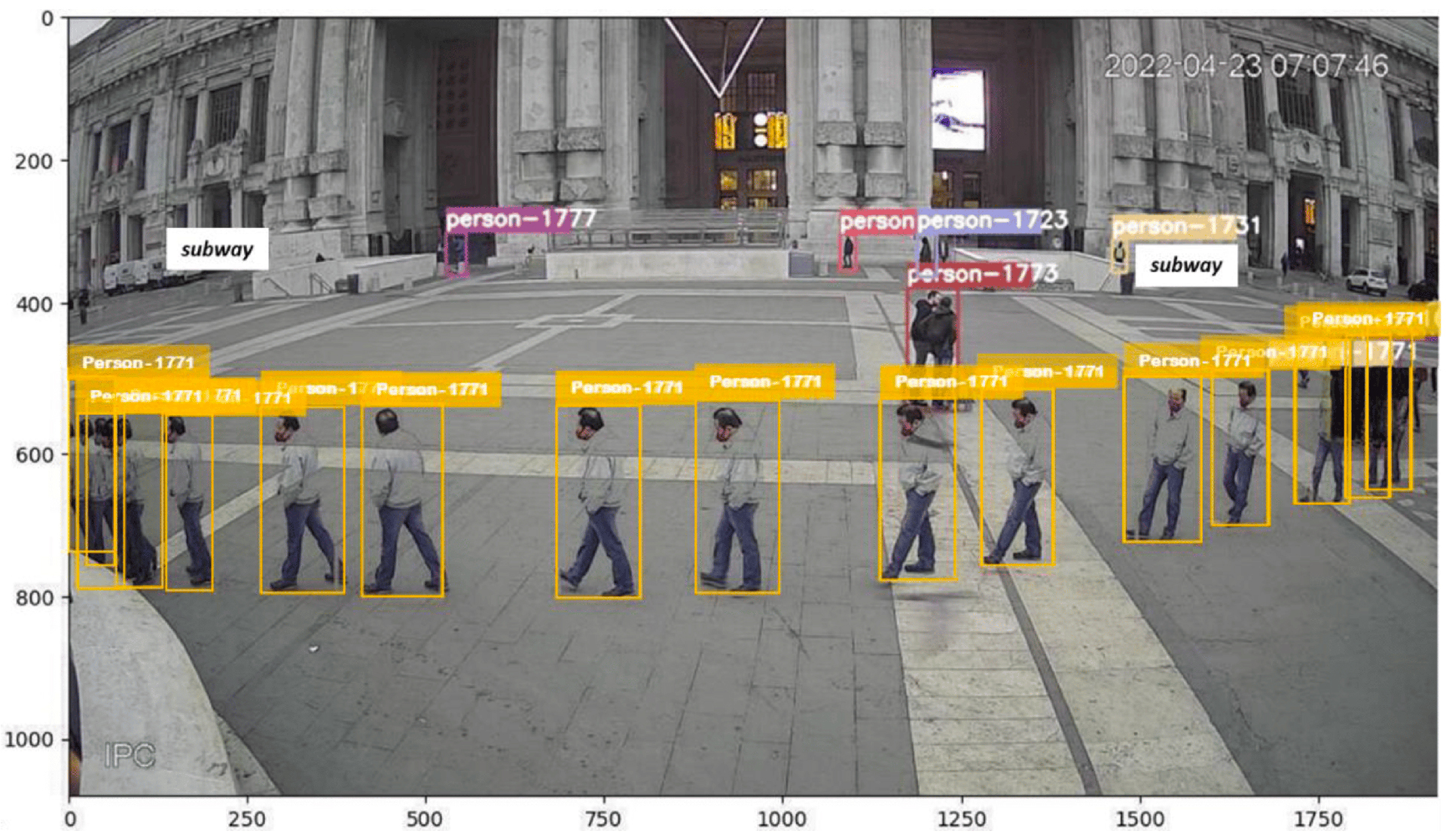
Example of detected persons whose assigned ID was tracked along their trajectory while crossing Piazza Duca d'Aosta in front of the Central Station
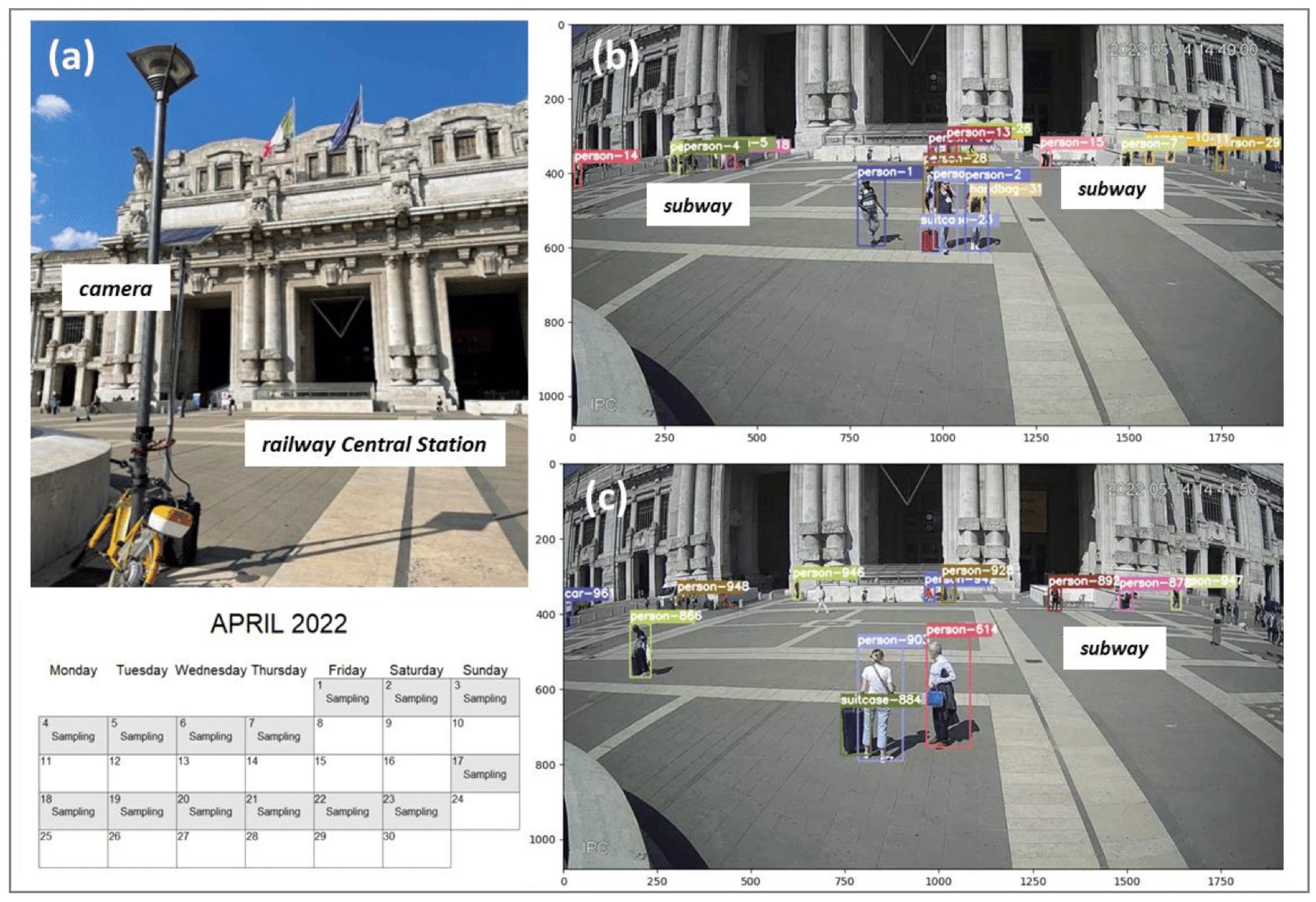
Example of detected persons whose assigned ID was tracked along their trajectory while crossing Piazza Duca d'Aosta in front of the Central Station