Italian National Agency for New Technologies, Energy and Sustainable Economic Development

MEDIA - Press office ENEA

Infrastructures: Sensors and drones for risk protection
3D models of bridges and viaducts, platforms for critical infrastructure and sensor networks, but also photogrammetric surveys, drones and training are some of the solutions to make infrastructures safer in the case of earthquakes or other disasters that ENEA presented at the conference "Existing bridges, viaducts and tunnels: research, innovation and applications", held in Genoa and organized by the Fabre Consortium. Among the other innovations presented by ENEA there is also an 'attention index' to identify maintenance interventions.
The Consortium, comprising ENEA, the Polytechnics of Milan and Turin, the Universities of Perugia, Padua, Pisa, Camerino, Messina, “Luigi Vanvitelli” of Campania and “Sapienza” of Rome, was created with the objective of evaluating the road infrastructure in our country and develop innovative techniques for the restoration of bridges, viaducts and other structures.
As part of the event, the ENEA Laboratory of Analysis and Protection of Critical Infrastructures, represented by Chiara Ormando and Alessandro Lipari, presented three studies on risk assessment and management for bridges and viaducts, in reference to the Italian Guidelines .
Specifically, an interdisciplinary group of researchers from the Laboratory has developed an index to easily identify the 'attention classes' for bridges and viaducts envisaged by the relevant Guidelines, useful for supporting studies and giving priority to maintenance interventions on the analysed works. The studies presented were developed and tested on a group of bridges and viaducts identified among those included in the inspection and analysis activities carried out by ENEA in the last two years. Furthermore, the outcomes may also be useful in reviewing current regulations.
As part of numerous research activities at a national and international level, the Laboratory has also developed the GIS-based platform CIPCast[1] for the monitoring and risk analysis of critical infrastructures. Working in both operational and simulation modes, the platform can produce expected damage scenarios based on the location of the infrastructural elements, their specific vulnerabilities and in the type of extreme event expected.
With the support of a large territorial database, CIPCast combines results from forecast models, data from in-situ sensors and information processed from satellite images. This information, spatially analysed with the geolocation of the infrastructures, contribute to define the expected risk and impact scenario.
“Satellite data can be used to analyse and monitor subsidence phenomena or, more generally, slow ground movements near infrastructures like bridges, viaducts and buildings" pointed out Maurizio Pollino, head of the ENEA Analysis and Protection of Critical Infrastructures Laboratory . "With regards to in-situ monitoring, it is also possible to install an adequate network of sensors to continuously verify the health status of the work and its components, provide indications, allow the development of applications aimed at early warning and suggesting any maintenance interventions".
The use of drones (remotely piloted flight systems, UAS) is also added to the combined approaches of GIS platforms (sensors and satellite). These devices allow you to carry out photogrammetric surveys of infrastructural elements, obtaining very high resolution orthophotos, 3D models and metric data of the structure.
The technique can support the assessment of the structural health of bridges and viaducts and is applicable both to improve models based on Building Information Modeling (BIM), providing on-site data (e.g. topography, progress updates, site conditions, etc.) and to update the models in real time.
To train experts in the sector, ENEA has also organized advanced courses in photogrammetric surveying with drones, divided into cycles of theoretical and practical lessons and operational flights, addressed at ENEA technicians and researchers and users involved in the Fabre consortium. During the courses, the methods for evaluating the different risks (static, foundational, seismic and hydrogeological) and promoting the verification, control and monitoring of infrastructures, developing innovative techniques in the repair and/or improvement of bridges viaducts and other structures and 3D digital models of the works, were explored in depth.
“Thanks to the courses it was possible to improve the phases of acquisition of geometric information of multiple structural typologies”, pointed out Antonio Di Pietro at the ENEA Analysis and Protection of Critical Infrastructures Laboratory. “This information, combined with a detailed knowledge of the dimensions of the structural elements, the external geometry, the consistency of the non-visible elements and the characteristics of the materials, represent essential elements to assess the state of the structures, in line with the technical standards” said Di Pietro.
During the last course in Umbria, a 3D digital model of the Beroide bridge, near Spoleto (Perugia), was developed and manufactured.
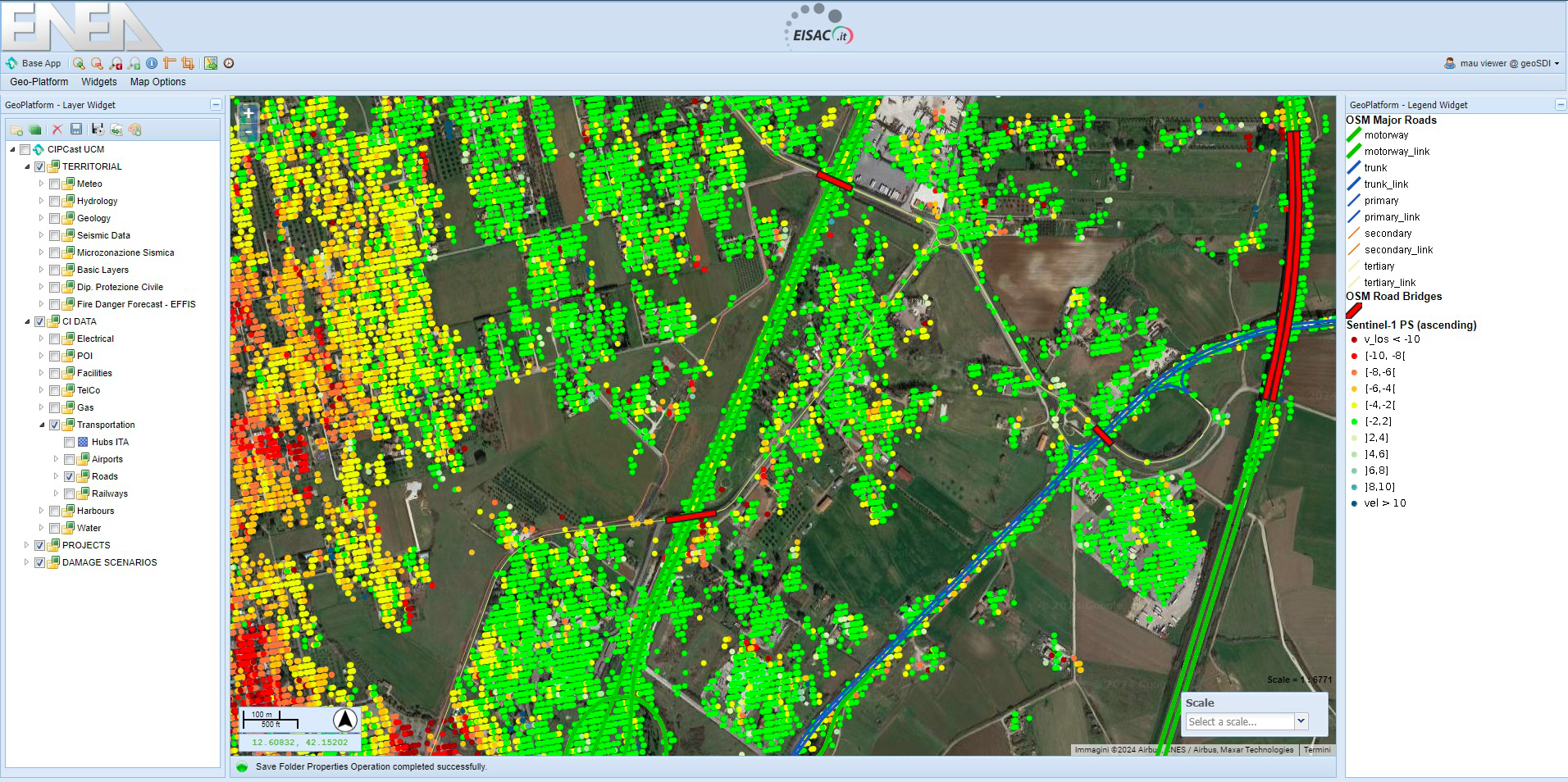
Screenshot of the CIPCast platform in which the InSAR Permanent Scatterers (PS) are displayed, superimposed on the geolocation of the road network and bridges/viaducts. This is a technique that allows numerous measurement points to be obtained, each characterized by a time series of displacement with an accuracy of the order of millimetres, useful for identifying deformation processes of the ground (past or in progress) and estimating their evolution in time and space.
Photos and videos


Other archive videos, freely reproducible, are available on request.